When the Ocean Breathes: Meteotsunamis in Western Europe
research updateMysterious tidal surges struck the coasts of UK, Ireland, France, and Spain in Summer 2022. Our investigation reveals these rare events were meteotsunamis: ocean waves triggered by atmospheric pressure disturbances.
A Summer of Strange Tides
On June 18, 2022, residents of Solva Harbour in Wales witnessed something extraordinary: the sea suddenly surged, creating massive whirlpools at the harbor entrance and pulling moored ships violently. Similar mysterious “tidal surges” were reported across Ireland, France, and Spain. A month later, on July 19, it happened again along the coasts of southern England and Wales.
These weren’t ordinary tides. It was a meteotsunamis, a rare and fascinating phenomenon that most people have never heard of.
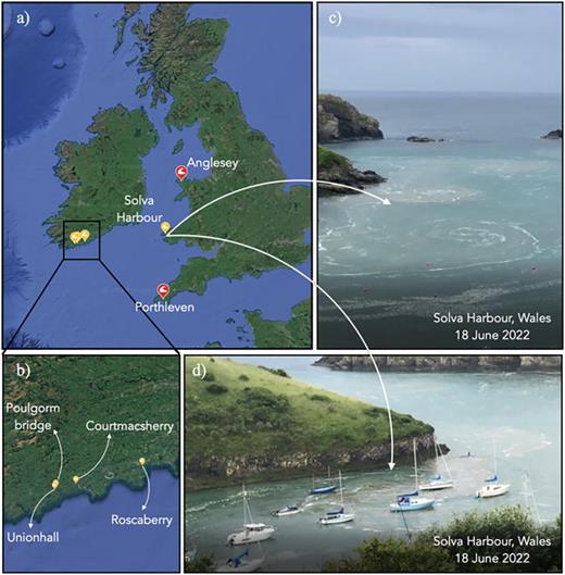 Map showing locations where anomalous tidal surges were observed on June 18 (yellow) and July 19 (red), 2022. Images show the dramatic whirlpool formation at Solva Harbour, Wales.
What Are Meteotsunamis?
Unlike the devastating tsunamis caused by earthquakes, meteotsunamis are generated by atmospheric pressure disturbances. Think of them as ocean waves triggered by rapid changes in air pressure as weather systems move across the sea.
What makes them particularly dangerous is their ability to amplify. When atmospheric waves travel at just the right speed, matching the speed of ocean waves in shallow water, a resonance phenomenon called Proudman resonance occurs. It’s like pushing a child on a swing at exactly the right moment: small atmospheric pushes can create surprisingly large ocean waves.
Meteotsunamis are rare events, which is precisely why understanding them is so important. Unlike regular tides that we can predict centuries in advance, meteotsunamis can appear with little warning, creating hazards for coastal communities, harbors, and maritime activities.
Unraveling the Mystery
In our recent study, Renzi et al. (2023), published in Physics of Fluids, we investigated what caused these Summer 2022 events across Western Europe. By analyzing:
- Atmospheric pressure fields at the surface and high altitude
- Sea level measurements from tide gauges across four countries
- Weather patterns and jet-stream data
We discovered that the June 18 events were indeed a series of meteotsunamis that propagated across Western Europe. They originated from localised pressure perturbations within a low-pressure system over the North Atlantic Ocean. Our analysis revealed that Proudman resonance amplified these waves as they traveled eastward along Ireland’s southern coast.
The July 19 events told a different story: these appeared to be seiching (oscillations in enclosed or semi-enclosed bodies of water) triggered by infragravity waves that resonated with wind-driven waves.
Why This Matters
Here’s the concerning part: Summer 2022 was the joint warmest summer on record in the UK, and Europe experienced its highest average temperature ever recorded. While we cannot directly link global warming to these specific meteotsunamis, warmer atmospheres hold more energy, increasing humidity, wind speed, and rainfall. These conditions favour meteotsunami formation.
As climate change drives more extreme weather and sea levels rise, understanding and predicting meteotsunamis becomes critical. Yet we found a significant gap: the UK records tide gauge data only every 15 minutes, while Ireland uses 5-minute intervals and France uses 1-minute intervals. Meteotsunamis have periods around 10 minutes: higher-resolution measurements are essential for accurately detecting and studying these events.
The Path Forward
We used numerical simulations with the Volna-OP2 model to reproduce the June 18 event, showing how atmospheric wave velocity influences ocean wave amplification. While our results matched observed wave heights reasonably well, modeling these events remains incredibly challenging. The atmospheric systems are complex, the affected regions are vast, and capturing all the small-scale features of bays and harbors that amplify these waves requires extremely high resolution.
The key message? We need:
- Better monitoring: High-frequency tide gauge measurements
- Early warning systems: Like those being developed for the Mediterranean
- Advanced models: Coupled ocean-waves-atmosphere systems that can predict these rare but dangerous events
As our climate continues to change, meteotsunamis may become more frequent visitors. Understanding them now could save lives and infrastructure in the future.
References:
- Renzi, E., Bergin, C., Kokina, T., Peláez-Zapata, D., Giles, D., & Dias, F. (2023). Meteotsunamis and other anomalous ‘tidal surge’ events in Western Europe in Summer 2022. Physics of Fluids, 35(4). https://doi.org/10.1063/5.0139220